Hello! I'm Alyssa Pacheco, an environmental science graduate with a passion for using data to drive sustainability. I recently began my journey into data science, and I'm excited to leverage my scientific background to tackle ecological challenges through machine learning and data analytics.

Throughout my studies, I've developed a strong skills in environmental analysis, GIS mapping, and research, and I'm currently honing my technical abilities in Python, R, and machine learning during my master's program. My goal is to bridge the gap between environmental science and technology to solve some of our planet's most pressing issues, like climate change and biodiversity loss.

Featured Work

Moving Valmeyer: GIS Parcel and Roads Update

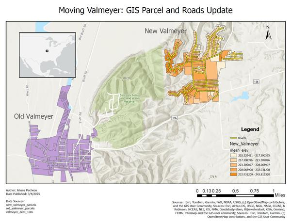
In this project, I worked as a GIS analyst to update parcel and road data for Valmeyer, Illinois, which was relocated to mitigate flood risks. Using ArcGIS Pro, I updated the parcel dataset with new attributes, including mean, minimum, maximum elevation, and slope. These updates support property assessment and emergency management analysis.

Additionally, I digitized a new road network to reflect the town’s relocation, providing essential routing data for emergency response. The final outputs were published as a public web map on ArcGIS Online found below, including:

Old parcel data (single color symbology)
New parcel data (symbolized by mean elevation)
Digitized roads layer

This project involved spatial analysis using Zonal Statistics and raster processing techniques to ensure accurate data integration for future planning and disaster preparedness.

Follow Me